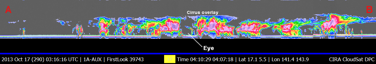
CloudSat overpassed Typhoon Francisco in the West Pacific on October 17, 2013 at 0407 UTC, the storm contained estimated maximum strength winds of 75 knots (86 mph) and minimum pressure of 967mb.
The Moderate Resolution Imaging Spectroradiometer (MODIS) on NASA's Aqua satellite captured the infrared (IR) image taken a few minutes before the CloudSat overpass (the blue line A-> B on Figures 1, 2 and 3). CloudSat overpassed about 12km to the west of the center of the storm revealing the structure of the eye and eye wall. The CloudSat overpass intersects the western portion of the eye and eye wall overlaid with cirrus. CloudSat intersected the core area of circulation surrounding the eye as well as the outer rainband regions containing convective cumulonimbus cells. The CloudSat overpass reveals the cirrus canopy covering most of the eye region and the mostly clear region beneath the cirrus overlay.
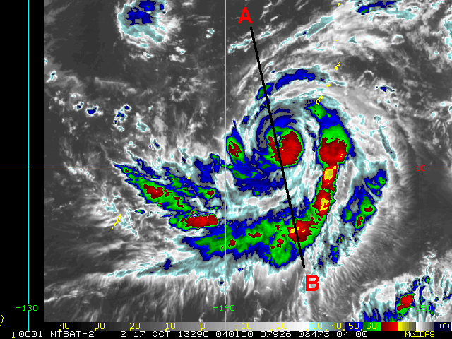
McIDAS-X imagery (4km remapped and color enhanced 11 um infrared imagery (IR)) from MSTAT is shown in Figure 3 and reveals the cold cloud tops (-70 to -80 C degree range with red and yellow color enhancement, respectively).
Figure 1. MODIS imagery of Typhoon Francisco.
Figure 3. 4km Remapped Color Enhanced Infrared Imagery (courtesy RAMMB).
Figure 4. CloudSat overpass.
Figure 4. Typhoon Francisco Animation - West Pacific, October 17, 2013.
References:
MODIS imagery, LAADS Web, Retrieved October 17, 2013.
4km Remapped Color Enhanced Infrared Imagery, Hurricane Henriette, Retrieved October 17, 2013.