|
News: 2009
|
 |
|
2009 CloudSat News
30 November 2009
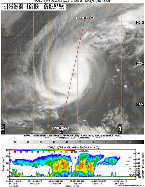
Typhoon Nida
CloudSat overpassed the eye of Typhoon Nida in the West Pacific on 11/28/09 AND 11/30/09. The overpass of Nida on the 28th captured the storms intensity - high cloud tops (~15 km), strong convection (red reflectivity) and heavy rainfall (denoted by the attenuation of the signal at the surface). The eye of the storm is ragged with cumulus/stratocumulus near the surface and partially covered with a thin cirrus layer. The eyewall slopes outward with equal amounts of deep convection on the north and south sides. The overpass on the 30th shows a much different picture, dry air entrainment from the NW and cooler SST's have weaked the storm considerably. The eye is much larger and the stronger convection is limited to the north side of the storm.
12 November 2009
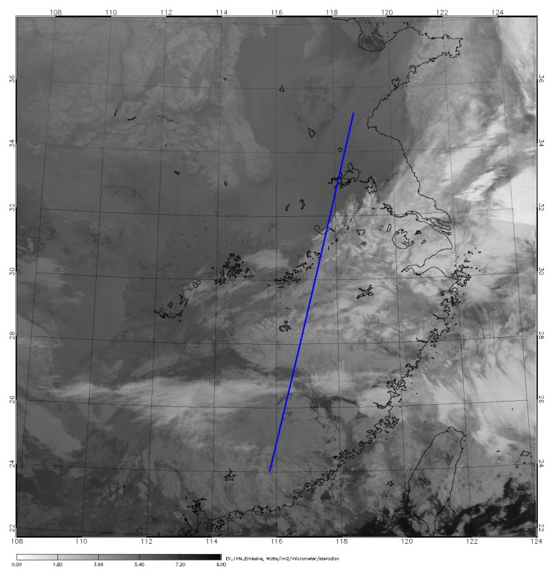
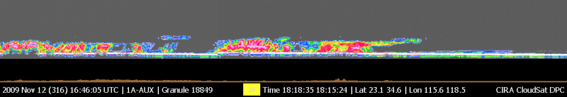
China Snow
An early season snow storm swept over parts of Northern China dumping heavy snow over the area. This was one of the worst snow storms in decades to hit northern China, over 32 people died, thousands of acres of crops were destroyed and 15,000 buildings collapsed. CloudSat overpassed part of the storm on November 12, 2009 at 18Z. The sensitivity of the CloudSat CPR can be used to estimate the vertical and horizontal snowfall distributions (Liu, 2009). The clouds from this overpass are shallower compared to convective tropical clouds over the ocean.
15 September 2009
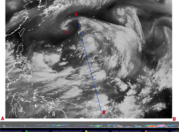
Typhoon Choi-Wen
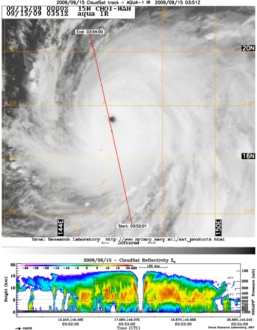
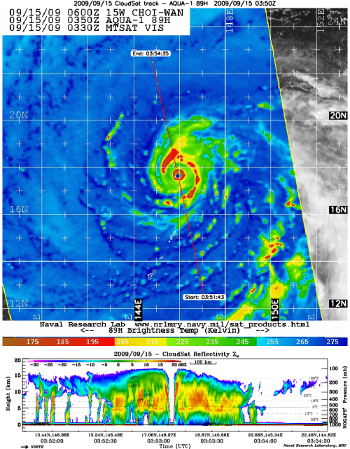
CloudSat completed an eye overpass of Typhoon Choi-Wan in the West Pacific on 9/15/2009 at 0352Z. The CloudSat overpass shows the vertical cross section right through the center of the storm. The eye center is cirrus free with eye wall edges sloping outwards towards the top of the storm with hot towers on both sides (denoted by the bright red bands outside the eye center in the AQUA AMSR-E 89 GHz image). The storm has a well developed, fully enclosed circular eye wall (red
circle) around the eye center with orange and red reflectivities (intense convection and precipitation) extending outwards. The AQUA IR depicts cloud cover throughout the overpass but the CloudSat image reveals moats (convection free areas) containing a thick cirrus canopy between the spiral rain bands. This is one a few inner eye images CloudSat has captured of an Category 4/5 tropical cyclone.
1 September 2009
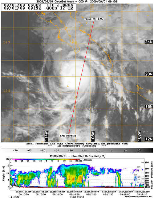
Typhoon Jimena
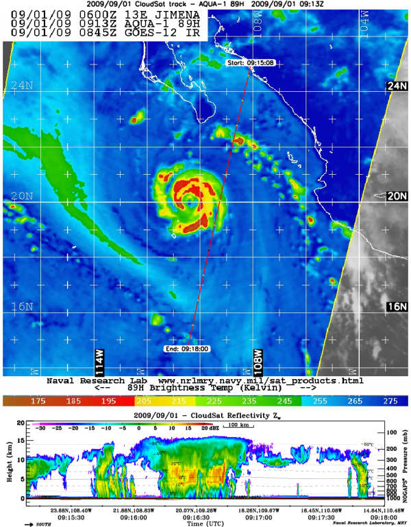
CloudSat made an overpass of Hurricane Jimena (winds 135 knots, 931 mb) as the storm was approaching the Baja peninsula on September 1, 2009. CloudSat overpassed just outside the ring of the deep convection. 89 GHz AMSR-E image shows the system completing an eye wall replacement cycle (noted by the almost complete red ring around the center of the storm). The GOES-12 IR image depicts the cloud cover of the storm, the CloudSat data shows convection concentrated to the core of the system with cirrus and small bands of convection in the outer region.
19 August 2009
Hurricane Bill eye overpass
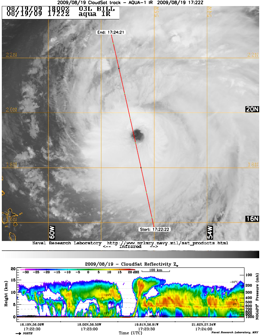
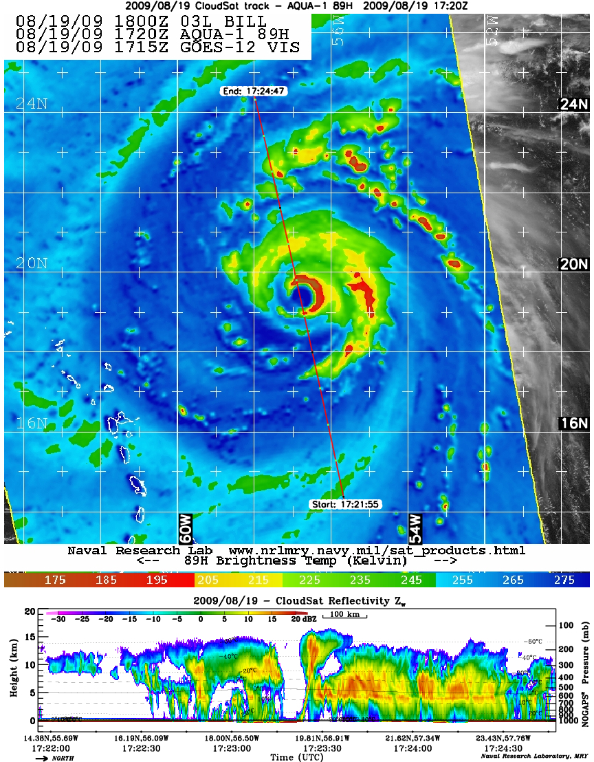
CloudSat made a remarkable overpass over the eye center of Hurricane Bill churning in the Atlantic. At the time of the CloudSat overpass, Hurricane Bill strengthened to a Category 4 (115 knot winds, 947 mb) while completing an eyewall replacement cycle. In the AMSR-E image, half of the eyewall is already completed (half red circle on right side of the CS image). The eye is completely cirrus free with intense reflectivies (red) surrounding the eye wall and the upper edges of the eyewall tilted towards the south.
13 August 2009
CEN Summer Newsletter
The CEN Summer 2009 newsletter is available for download.
7 August 2009
Typhoon Morakot
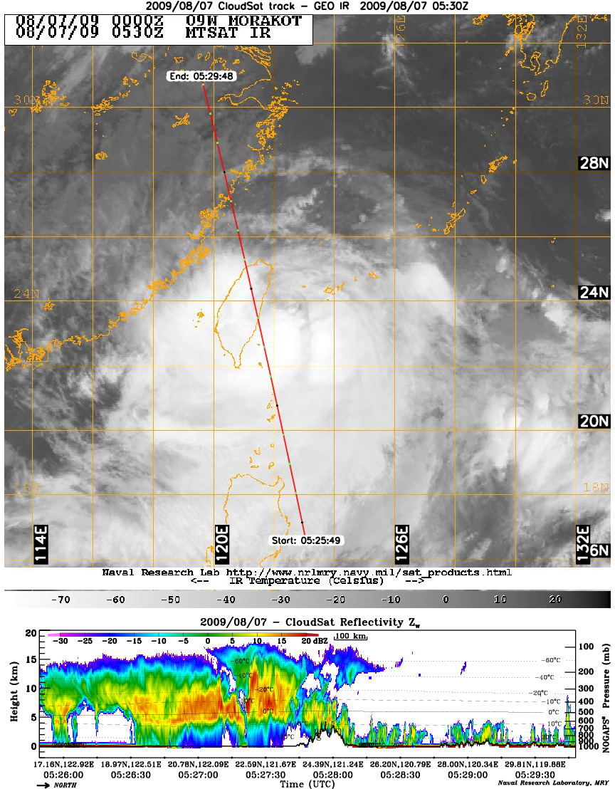
Typhoon Marokot approached Taiwan on August 7, 2009 with wind speeds of 80 knots (92 mph) and torrential rains. CloudSat passed directly over the system at 0530 UTC providing a view of the inner structure of intense convection and heavy rains in the sw quadrant of the storm. Typhoon Marokot dumped up to 80" of rain in parts of Taiwan causing devastating mudslides and wide spread flooding.

4 August 2009
TS Morakot
CloudSat profiled the western portion of tropical storm Morakot on August 4, 2009. Morakot is an example of TC formation from a monsoon system (gyre) that formed over the western North Pacific in late July. In this overpass, Morakot is just beginning to strenghten as it gains intensity by moving into warm sea surface temperatures and low wind shear - ideal conditions for TC development.
29 July 2009
North Pacific gyre overpass
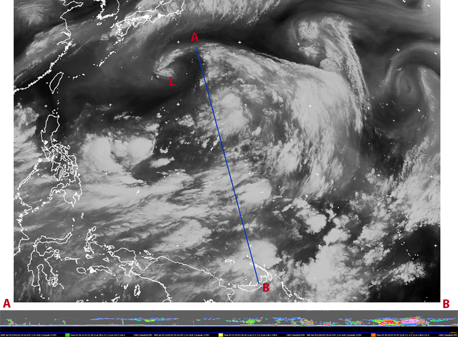
Cloudsat completed an overpass of a large monsoon system located in the West North Pacific ocean known a gyre. A gyre is a monsoon event containing strong, large scale wind patterns and a cyclonically curved swirling center vortex encompassing a large area in the ocean. The IR image was obtained at 0300 UTC 07/29/09 from the MSTAT satellite. CloudSat overpasses directly through the system covering ~3600 km. Info on what a monsoon gyre can be found in the following paper by Mark Lander: Description of a Monsoon Gyre and Its Effects on the Tropical Cyclones in the Western North Pacific during August 1991, Lander, M.A., Wea and Forecasting, 9, 640-654.
25 June 2009
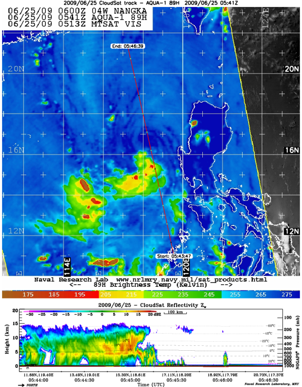
Eye overpass of TS Nangka
CloudSat made an eye overpass of a weakening tropical storm Nangka in the West Pacific on June 25, 2009. TS Nangka encountered an area of high wind shear to the north of the storm as depicted by the lack of clouds and precipitation in the right hand side of the CloudSat overpass. They eye of the storm is denoted by the faint dark blue circle in the AMSR-E image (left image).
3 June 2009
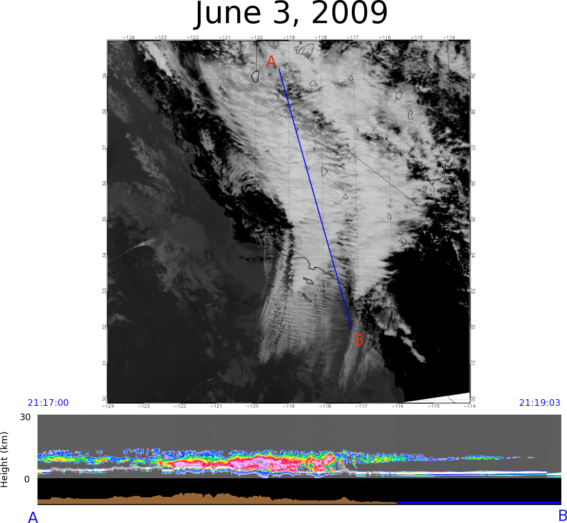
Altocumulus undulatus
CloudSat overpassed a layer of altocumulus undulatus over parts of California on June 3, 2009. Altocumulus undulatus forms as a result of wind shear and instability at cloud level. In this case, strong upper level northerly winds combined with a storm approaching from the west resulted in this unique cloud layer. The small ripples detected by CloudSat are found at the top of the cloud layer with scattered showers throughout the thicker part of the cloud deck.

15 April 2009
CEN Newsletter - Spring 2009
The 3rd edition of the CEN Newsletter is available for download!
5 April 2009
CloudSat overpasses Typhoon Jade
CloudSat made an overpass of Typhoon Jade just as the storm was making landfall in Madagascar on April 5, 2009. CloudSat overpassed the western eyewall edge of the storm, winds at this time were 65 knots (33 m/s) making it a minimal category 1 typhoon. Deep convection and heavy precipitation is evident from the red and orange patches throughout the storm overpass as well as the cirrus anvil blanketing the top of the storm.
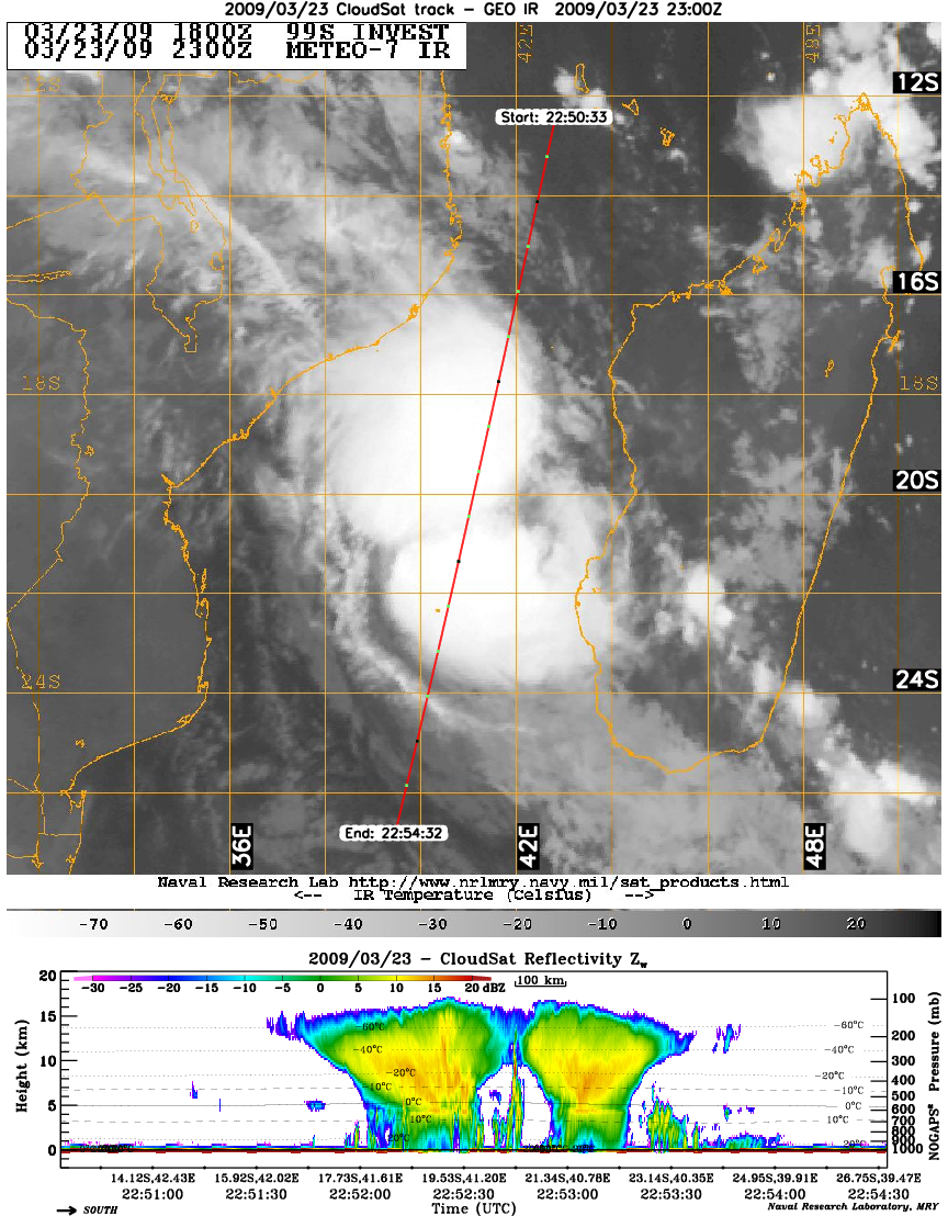
CloudSat profiles a developing TC Izilda
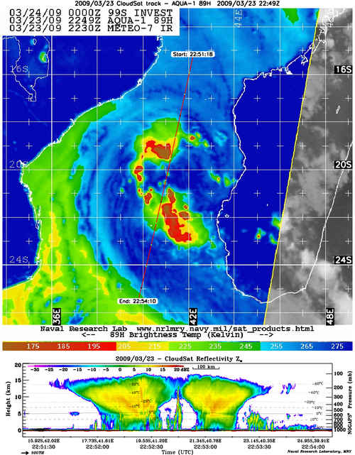
CloudSat profiled a developing tropical cyclone Izilda located in between Africa and Madagascar on March 23rd, 2009. In this overpass, Izilda was in the process of transitioning from a tropical depression to a tropical storm with winds of 30 knots. CloudSat passed through the edges of two convection cores of the storm, the intense developing convection is evident from the orange and red reflectivities in the center of the core convection. Izilda strengthened to max winds of 60 knots in less than 48 hours after this overpass, just shy of becoming a category 1 tropical cyclone.
CloudSat profiles US midwest storm
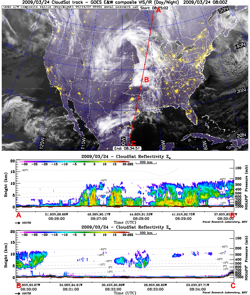
CloudSat completed two overpasses of a strong storm system moving across the central US on March 23rd and 24th, 2009. The March 23 overpass intersects heavy snowfall occurring over parts of Wyoming and Colorado. Some areas of Wyoming and western South Dakota recorded snowfall amounts in excess of 25" from this event. During the March 24th overpass, CloudSat intersects an area of dissipating severe weather over parts of Missouri and Iowa. Earlier in the evening squall lines developed ahead of the storm system as the upper level low tracked over the Dakotas. The system also has the appearance of the classic comma shape observed with mid-latitude systems as they move across the US.
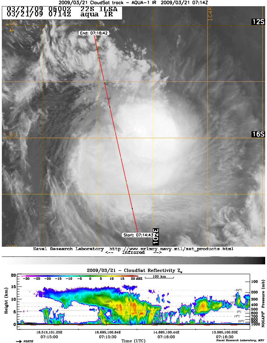
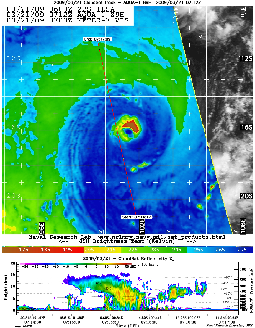
CloudSat profiles Tropical Cyclone Ilsa
CloudSat made an overpass through the left outer wall region of a weakening Tropical Cyclone Ilsa with winds of 98 mph (85 knots). At the height of the storms intensity on March 19th, 2009, Ilsa contained winds of 110 mph (96 knots), strengthing into a Category 4 cyclone off the western coast of Australia. As the storm moved further west of Australia, it weakened as it encountered mid-level dry air and cooler SST's. The overpass example here shows the dry air being entrained into the southern edge of the storm (causing convection to weaken) while the northern portion of the storm contains more convective areas.
|