|
News: 2008
|
 |
|
2008 CloudSat News
CloudSat profiles Tropical Cyclone Billy
CloudSat made a near eye overpass of Tropical Cyclone Billy on December 25th, 2008 as the storm moved off the coast of Western Australia. The storm contained winds of 60 mph (100 km/hr) at the time of this overpass. Billy intensified as the storm moved off the Australian coast into warmer waters but later weakened as the storm moved into cooler waters and stronger wind shear.

CEN Newsletter - Winter 2008
The 2nd edition of the CEN Newsletter is available for download!
CloudSat Team visits Cameroon - Video
Peter Falcon, a JPL member of the CloudSat Educational Outreach Team, recently made an outreach visit to two CloudSat Education Network (CEN) schools located in Cameroon. While in Cameroon, his interactions with the students and teachers was videotaped - you can see the video by clicking on the image above (131MB, QuickTime .mov format.)
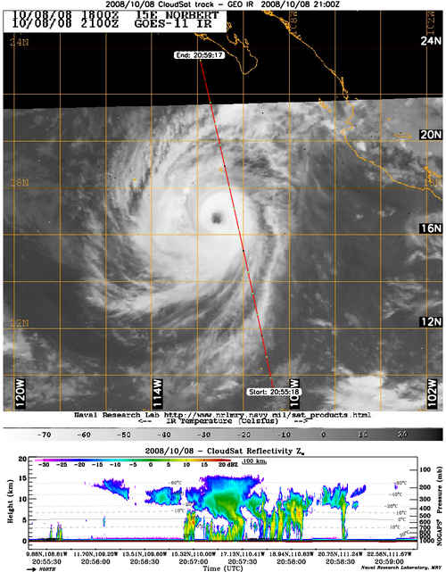
CloudSat overpass of Hurricane Norbert
CloudSat completed an overpass of a Category 4 Hurricane Norbert in the eastern Pacific on October 8, 2008. The storm contained winds of 115 kts (132 mph) and had just completed a period of rapid intensification (from 75 kt to 120 kt in 24 hrs). The CloudSat overpass shows how limited the convection is on the east side of the storm as evident by the small amount of bright red and yellow bands.
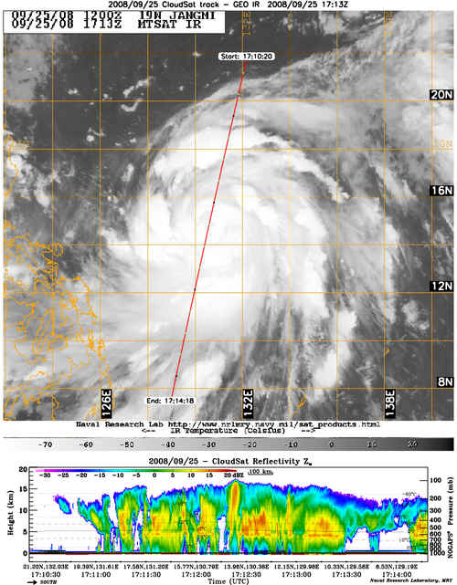
CloudSat completes an eye overpass of Typhoon Jangmi
CloudSat completed an eye overpass of a strengthening category 1 Typhoon Jangmi with winds of 80 knots (92 mph) on September 25th. You can visibly see the eye of the storm from the AQUA image that is overlaid with cirrus from the infrared imagery. Strong convection is evident inside the eyewall by the overshooting bright red and yellow bands up to almost 16 km's in the atmosphere.
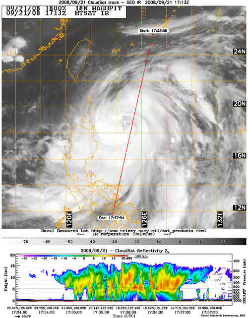
CloudSat makes a near eye overpass of Typhoon Hagupit
CloudSat completed a near eye overpass of Typhoon Hagupit on September 21, 2008. At this time the storm had winds of 75 knots (86 mph) as it was moving towards the Phillipines. The storm went through a period of intensification just after this overpass (25 kt from 21/1800Z to 22/1800Z) as evident by the numerous red and yellow bands of convection found throughout the storm overpass indicating strong upward vertical motion. Typhoon Hagupit caused extensive damage in the Phillipines, Hong Kong, Taiwan, China and Vietnam.
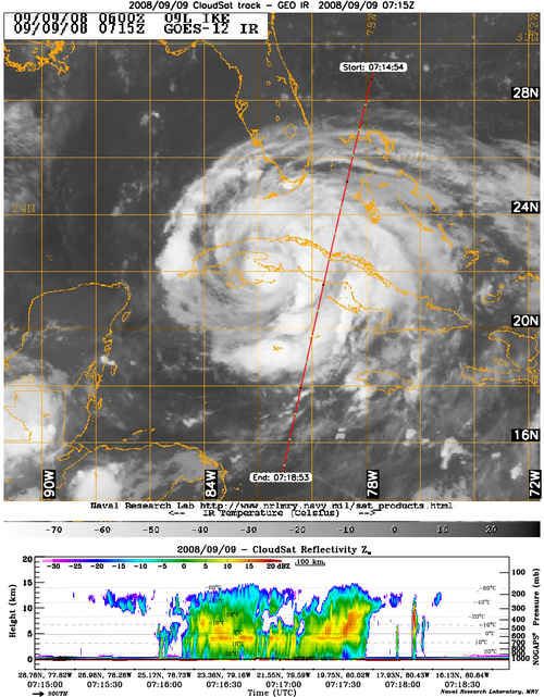
CloudSat revisits Hurricane Ike near landfall over Galveston
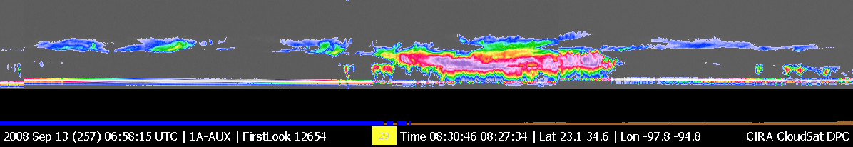
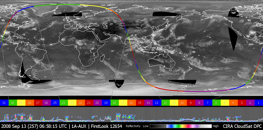
On Saturday, 13 September, around 0700 UTC, CloudSat made a descending-node
overpass of the northwest quadrant of Hurricane Ike as it made landfall over
Galveston, TX. In the QuickLook image above, the segment of Ike that CloudSat
sampled is about 400km (250 miles) wide, and clouds extended from the surface
to almost 20 km (~12 miles) high in the atmosphere. Heavy precipitation in
this segment of Ike is evidenced by the disappearance of the surface return
signal (normally, the bright white stripe at the bottom of the clouds).
Hurricane Ike made landfall near Galveston, TX with an estimated surface wind speed of 95 knots, and a central pressure of 952 mb. The strong Category-2 hurricane brought heavy rain and an estimated 13.5-foot storm surge, knocking out
power to nearly 4.5 million Houston residents and causing damage to buildings over a large area.
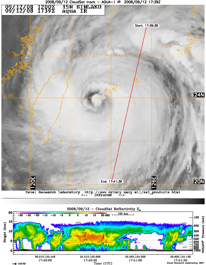
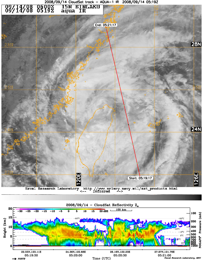
CloudSat profiles Typhoon Sinlaku
CloudSat completed two overpasses of typhoon Sinlaku in the western Pacific. The 9/12 overpass shows the heavy rain in the eastern portion of the Category 2 storm and a near eye overpass on 9/14.
CEN Newsletter
The first volume of the CloudSat Education Network newsletter is available for download. This issue contains lots of great information and examples on how the network involves schools and kids in using CloudSat data.
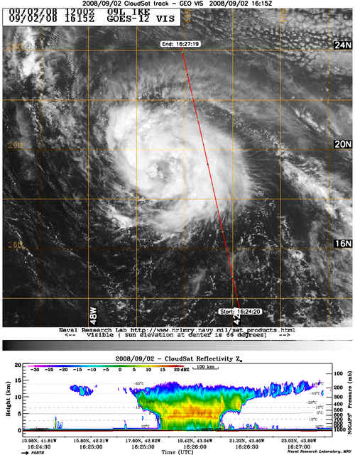
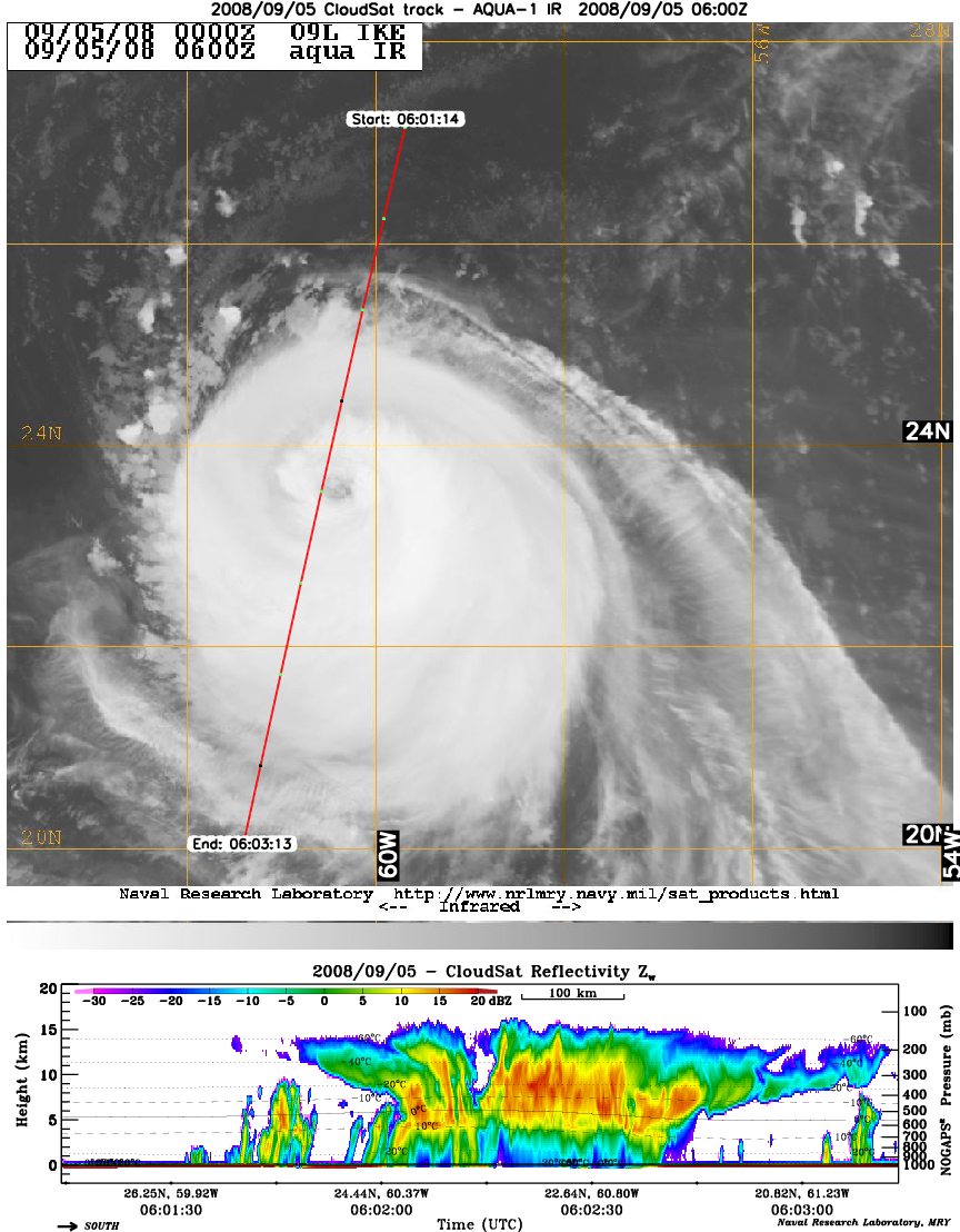
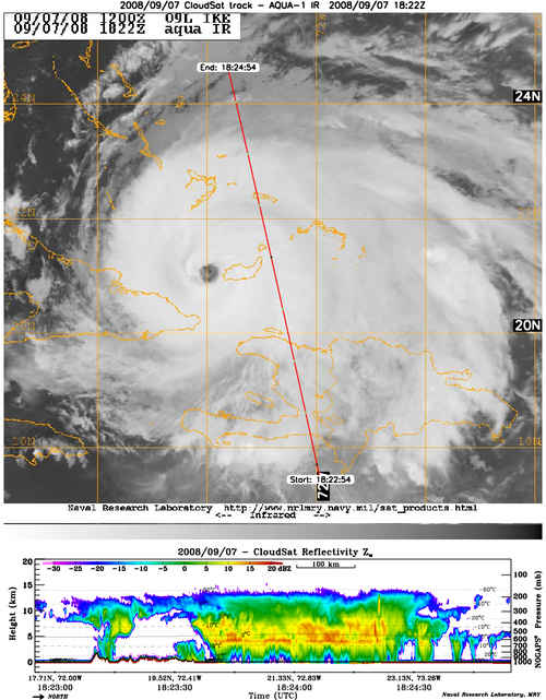
CloudSat profiles Hurricane Ike
CloudSat has made four overpasses of Hurricane Ike as the storm churned through the Caribbean and Gulf of Mexico. The overpass on 9/5 intersected the western portion of the eye wall of the cyclone with sustained winds of 110 knots and gusts to 135 knots. The 9/7 overpass of the eastern portion of the storm clearly shows the wide rain bands and heavy precipitation evident by the attenuation of the radar near the surface.
CloudSat profiles Hurricane Gustav
CloudSat profiled Hurricane Gustav on September 1, 2008 as the storm made landfall in Louisiana. Gustav was the seventh tropical cyclone, the second major hurricane of Atlantic season and caused widespread damage across Haiti, the Dominican Republic, Jamaica, Cuba and the United States. The CloudSat overpass shows the storm is quite compact with rain falling in a small area although the cloud fields make the storm appear much larger.

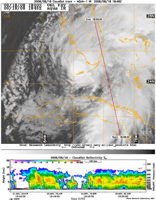
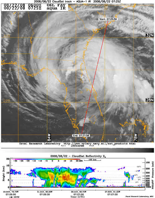
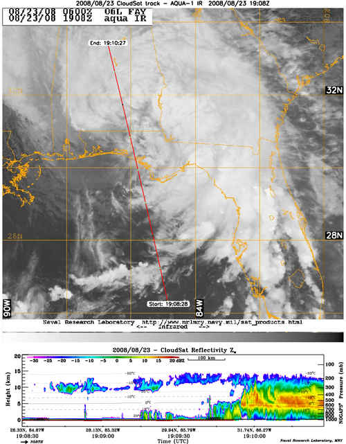
CloudSat profiles TS Fay
 |
 |
 |
| Click for full-size image |
CloudSat completed three overpasses of Tropical Storm Fay, which made a record breaking four landfalls over Florida during the 2008 Atlantic tropical season. TS Fay produced heavy rains over nearly every county in Florida after battering central Cuba with rain and winds up to 85km/hr. Two overpasses of Fay were made on 18 August as the system approached the southern tip of Florida, another on August 22 as Fay spun over central Florida and one on August 23 as the system exited Florida.
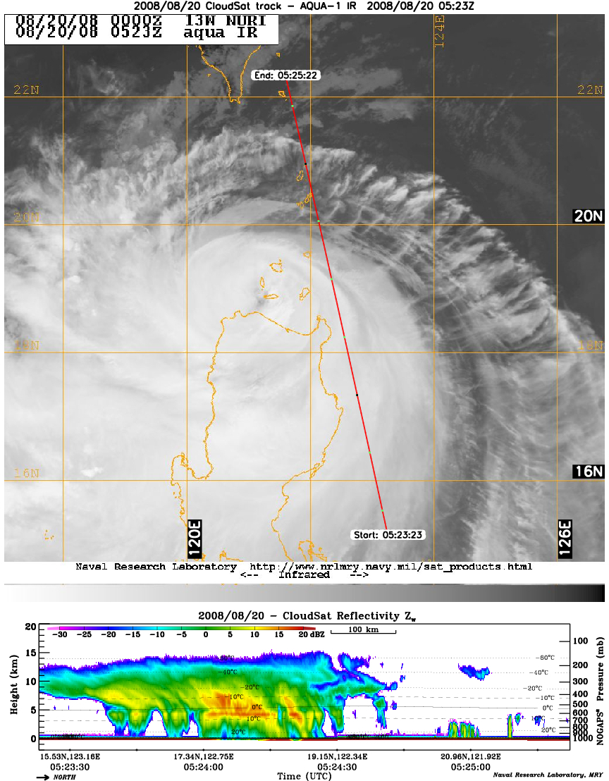
Typhoon Nuri overpasses
CloudSat completed two overpasses of Typhoon Nuri on August 20 & 21, 2008. Typhoon Nuri first made landfall in the Phillipines packing winds of 90 knots in the August 20th overpass. On August 21st, CloudSat made an overpass of TS Nuri as it traveled towards Hong Kong and made a direct hit to the city on August 22, 2008.
CloudSat Receives NASA Exceptional Service Medals
Congratulations to the following members of the CloudSat team who have received NASA award medals!
- Dr. Graeme Stephens received the NASA Exceptional Public Service Medal for service to NASA and the nation as the CloudSat Principle Investigator.
- Deborah Vane received the NASA Exceptional Achievement Medal for contributions to the CloudSat mission in the roles of proposal manager, deputy principle investigator, and project manager.
- Brian Pieper received the NASA Exceptional Public Service Medal for delivering the CloudSat spacecraft bus and preparing the spacecraft for launch and early orbit operations.
- Dr. Don Keenan received the NASA Exceptional Public Service Medal for developing the theoretical basis used to fly CloudSat in formation with CALIPSO and the A-Train satellites.
- Phil Partain received the NASA Exceptional Public Service Medal for the design and implementation of the Level 2 software infrastructure for the CloudSat Data Processing System.
- The CloudSat Algorithm Development Team received a NASA Group Achievement Award for exemplary development and implementation of the CloudSat Standard Data Product algorithms.
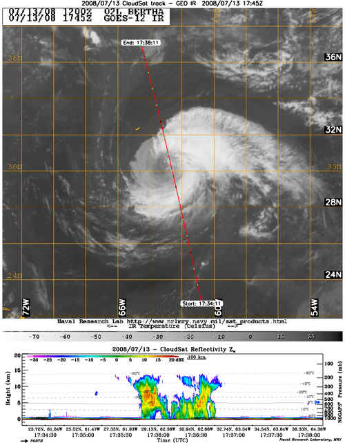
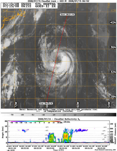
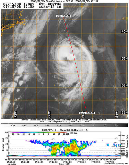
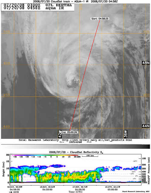
CloudSat completes four overpasses of TS Bertha
CloudSat has made an astounding four overpasses of the eyewall of the second Atlantic tropical storm of the 2008 season. Tropical Storm Bertha, which has become the longest-lived July tropical storm on record, is currently 360 miles northeast of Bermuda and moving slowly to the southeast. The relatively slow movement of the storm system has contributed to the number of eyewall overpasses by CloudSat, including the two most recent overpasses, taken just eleven hours apart.
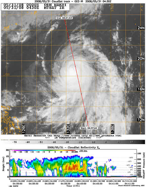
CloudSat Profiles Typhoon Nakri
CloudSat profiled Typhoon Nakri on May 31, 2008 at 0600. Typhoon Nakri became the third typhoon and second super typhoon in the month May, the first time since 1959 the North Pacific has seen 3 typhoons during the month of May. Nakri rapidly intensified on May 29 to an equivalent Category 4 typhoon but weakened by the time of the CloudSat overpass on May 31 with winds speed of 85 knots.
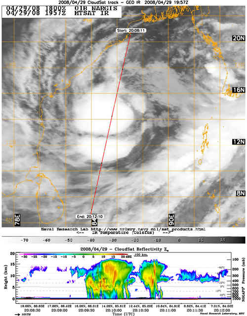
CloudSat Profiles Cyclone Nargis
Cyclone Nargis, which has caused such extensive damage and loss of life in Burma (Myanmar), was profiled during daytime (0756 UTC) and nighttime (2010 UTC) overpasses by CloudSat on 29 April 2008, when it was centered over the western Bay of Bengal. Rainfall accumulations estimated from the Tropical Rainfall Measuring Mission (TRMM) satellite are available at the NASA Earth Observatory.

 [Images courtesy of the Naval Research Laboratory-Monterey]
Graeme Stephens Receives International Honor for CloudSat
Graeme Stephens, a University Distinguished Professor and director of the Cooperative Institute for Research in the Atmosphere at Colorado State University, has been awarded the top honor from NASA for his exceptional scientific leadership of NASA's CloudSat mission launched in 2006.
Earlier this fall, the International Association of Meteorology and Atmospheric Sciences presented Stephens with the International Radiation Commission Gold Medal - an honor it only presents once every four years - during the Radiation Symposium in Iguacu, Brazil. The Gold Medal honors a scientist who has made contributions of lasting significance to the field of radiation research.
April 2008
CloudSat Second Anniversary
CloudSat reached its second anniversary in orbit on Monday, 28 April 2008. CloudSat completed its 22-month prime mission on 27 February and is now in extended mission phase. From its initial transition to operational mode on 2 June 2006 through the end of April 2008, CloudSat has collected 9908 granules (orbits) of data, including 367 million radar profiles and 45.9 billion individual radar bins (vertical measurements). The CloudSat Data Processing Center has distributed 1,725,299 product files, totaling 119 terabytes of data to scientists in 47 different countries.
CloudSat wins RNASA Stellar Award

On Friday, 25 April 2008, CloudSat received a Rotary National Award for Space Achievement (RNASA) Foundation Stellar Award at the annual RNASA banquet.
Along with the National Space Trophy awarded to Gene Cernan, the last astronaut to stand on the Moon, CloudSat was honored at the banquet for "exceptional achievement by an international joint government, university and industry team in conceiving, designing, developing and launching the CloudSat spacecraft that provides an unprecedented three-dimensional perspective of Earth's clouds to answer questions about how they form, evolve, and affect the weather, climate and fresh water supply."
More information about the RNASA Stellar Award can be found at:
http://www.stellarawards.org/about_rnasa.html
5 February 2008
-
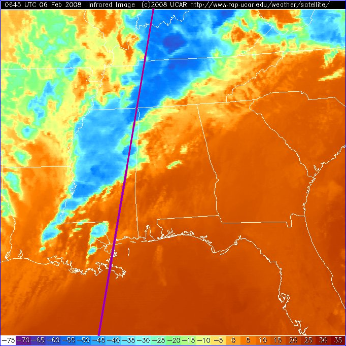
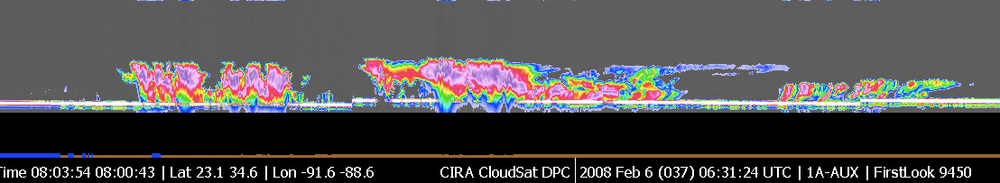
CloudSat made a nighttime overpass (approximately 0630 UTC) of the thunderstorms responsible for the tornadic outbreak over Kentucky, Tennessee, and Mississippi on Tuesday, 5 Februrary 2008. This extensive tornado outbreak, which is responsible for more than 50 fatalities and billions of dollars in damage, occurred in the late evening and throughout the night of the 5th into the 6th of February.
The upper image is a nighttime color infrared image from GOES with an overlay of CloudSat's descending track. CloudSat transited the region from north to south, and captured the convective outbreaks over Kentucky and Tennessee, then observed the convection over eastern Mississippi. The lower image combines CloudSat QuickLook images from segments 28 and 29 taken from CloudSat granule number 9450. The intensity of the convection is particularly evident in the CloudSat image - large regions of radar attenuation are seen (represented by a lack of surface signal return in the radar image) as well as evidence of multiple scattering (seen in the radar image as a sub-surface return) due to the large hail present in these systems.
Storm reports from this outbreak are available online from NOAA-SPC: http://www.spc.noaa.gov/climo/reports/080205_rpts.html
18 January 2008
-
On 18 January, the CPR (Cloud Profiling Radar) was transitioned from Operate Mode to Intialize Mode by autonomous fault protection. Initial analysis showed that two body current trips occurred in the High Power Amplifier -2 (HPA2). The spacecraft was in Sun, power was nominal and ADCS was nominal. This incident is similar to another that occurred in April 07. HPA body current trip events are known and expected, but the cause of the termination of the restart sequence after two (as in April 07), rather than three, sequential trip events, is under investigation.
The CPR was ground-commanded to Transmit Mode on Tuesday, 21 January, and
is collecting data. Both the CPR and spacecraft are healthy and
functioning nominally.
|