|
News: Tropical Storm Barry
|
 |
|
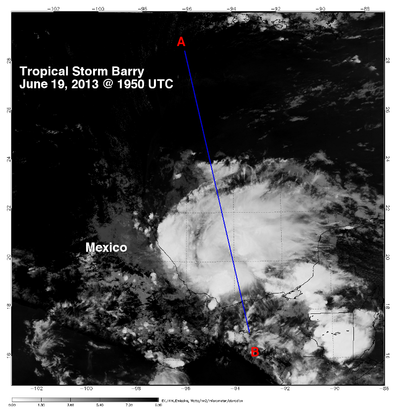
Tropical Storm Barry
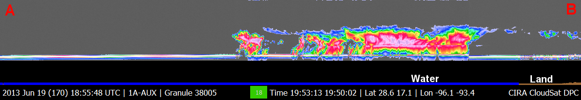
CloudSat overpassed Tropical Storm (TS) Barry in Gulf of Mexico on June 19, 2013 at 1950 UTC. At the time, TS Barry contained sustained winds of 35 knots (40 mph) making Barry the second named storm of the Atlantic hurricane season. CloudSat (blue line) intersects Barry east of the storm center. MODIS (aboard the A-TRAIN satellite AQUA) and the CloudSat cloud profiling radar (CPR) track are shown in Figures 1 and 2. The MODIS imagery in Figure 1 is a natural-color image and Figure 2 is the MODIS Infrared (IR) imagery both taken at 1950 EDT. The CloudSat cross section is shown below the MODIS imagery, A and B designate the starting and ending points of the overpass.
CloudSat overpassed just outside of the storm center revealing a large area of light to moderate precipitation throughout the system. The bright pink and deep red colors in the CloudSat imagery show areas of larger sized precipitation particles and heavier precipitation. Maximum cloud top heights in Barry are around 16 km with a wide area of deep convective clouds and rainfall. The cirrus canopy extends only slightly over the convective cell regions with a majority of the cloud types being cumulonimbus and cumulus types. This CloudSat overpass of TS Barry provides a unique satellite remote sensing tool for examining detailed cloud structure and position of convective cores in the system.
TS Barry underwent a burst of convective activity in the hours preceding the CloudSat overpass. Decent amounts of ocean heat content, high environmental moisture (total precipitable water) amounts and low wind shear allowed the storm to strengthen briefly but westward movement of the system towards land will inhibit further intensification. Heavy rainfall is expected over a large portion of southern Mexico as the storm moves inland.
| MODIS imagery with CloudSat intersect
|  |
|
GOES satellite imagery and animation with the CloudSat cross section is shown below for TS Barry.
References:
National Hurricane Center, Retrieved on June 20, 2013, TS BARRY Advisory Archive.
CloudSat Data Processing Center, Retrieved on June 20, 2013, CloudSat DPC.
MODIS Imagery, Retrieved on June 20, 2013, FTP Site.
|


