|
News: Remote Sensing Of Tropical Cyclones
|
 |
|
What Does CloudSat Do All Day? Watch Cyclones!
CloudSat, launched in 2006, belongs to the A-Train, a constellation of satellites that pass over the equator 14 times a day, and pass over the same locations every 16 days. Orbiting the Earth for a decade means that CloudSat has amassed an incredible amount of data about tropical cyclones (and far more about normal clouds and precipitation), even despite the battery anomaly it had in 2011 which limited it to only gathering data during daylight hours. Although few of its overpasses are directly over a tropical cyclone (the large majority of the overpasses are in the 500-900 km area away from the center of storms), this means that CloudSat can provide interesting scientific data on the environments around tropical cyclones, and particularly on the behavior of the clouds around those storms.
Even though CloudSat rarely intersects storms fully, sometimes the constellation and planet align, and it gets a perfect intersection, as it did for Typhoon Choi-Wan in 2009. Tourville et al. describe the host of data products that CloudSat gathers both when it crosses a storm, and when it misses it by a few hundred kilometers. Both occurrences provide much knowledge that is of incredible value to the science community wishing to better understand tropical cyclones, from their start to decline, as well as the environment around them.
To read more about CloudSat and the A-Train, as well as how this data can be used to better study and understand tropical cyclones, read the full article here: http://dx.doi.org/10.1175/BAMS-D-13-00282.1
CloudSat Product tags: CPR, ECMWF-AUX, MODIS-AUX, 2B-GEOPROF, 2B-GEOPROF-LIDAR, 2B-CLDCLASS, 2B-CWC, 2C-RAIN-PROFILE, 2C-PRECIP-COLUMN, 2B-FLXHR, 2B-TAU
Synopsis Author: Kalina Velev, JPL
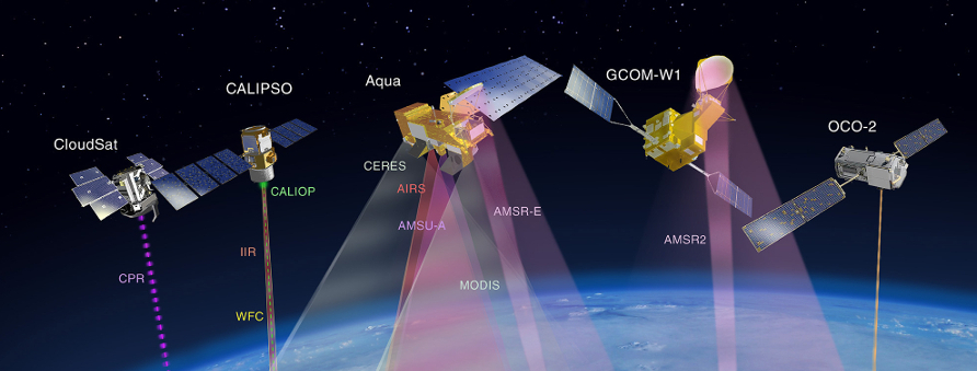
Figure 1. A-Train constellation of satellites.
|


