|
News: 2010
|
 |
|
2010 CloudSat News
|
|
|
 |
11 NOVEMBER 2010 | CloudSat Education Network
CEN Fall 2010 Newsletter
The Fall 2010 CloudSat Education Network newsletter!
|
|
|
|
|
|
 |
23 SEPTEMBER 2010 | CloudSat TC Overpass
Typhoon Malakas
CloudSat overpassed Typhoon Malakus on September 23, 2010.
|
|
|
|
 |
17 SEPTEMBER 2010 | CloudSat In the News
GRIP, CloudSat and Hurricane Karl Observations
Three of NASA's science aircraft completed successful coordinated flights over Hurricane Karl on Thursday, Sept. 16, in the southern Gulf of Mexico.
|
|
|
|
 |
2 SEPTEMBER 2010 | CloudSat Overpass
Tropical Storm Hermine
JPL produces animation depicting CloudSat overpass of Tropical Storm Hermine
|
|
 |
2 SEPTEMBER 2010 | CloudSat Overpass
Hurricane Earl
JPL produces animation detailing internal structure of Hurricane Earl using CloudSat data
|
|
 |
18 AUGUST 2010 | CloudSat Overpass
Pakistan Flooding
CloudSat intersects thunderstorms over areas in Pakistan responsible for the devastating flash floods.
|
|
 |
9 AUGUST 2010 | CloudSat In the News
Send in the Clouds
CloudSat's view of the clouds during the past four years.
|
|
|
|
|
|
|
|
|
|
 |
8 JULY 2010 | CloudSat in the News
NASA's Hurricane Research Project
CloudSat will play a key role in supplying data for the Summer 2010 GRIP hurricane research project.
|
|
 |
2 JULY 2010 | CloudSat Overpass
Heavy Rains in China
Heavy rains in southern China during June have killed hundreds and left thousands homeless.
|
|
|
|
 |
16 JUNE 2010 | CloudSat Overpass
Flooding in France
One of the worst floods in 180 years swept across southern France killing at least 25 people
|
|
 |
1 FEBRUARY 2010 | CloudSat CEN Newsletter
CEN Winter Newsletter
The latest release of the CloudSat Education network newsletter is available.
|
|
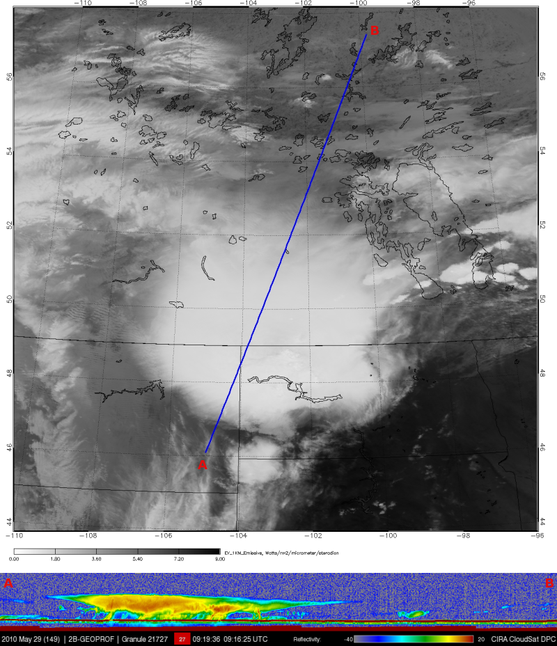
An early morning thunderstorm (0915 UTC) moved across portions of Montana, North Dakota and Canada bringing heavy rain and small hail to the areas. CloudSat overpassed the western section of the storm providing a unique vertical view of the storm. The cirrus canopy extends well beyond the core of the storm from the overshooting clouds tops hitting the tropopause and spreading out. Heavy rain is contained in the red and orange reflectivity's with some of the heavier precipitation attenuating in the lower 5 km of the storm. A cold trough moved through the area, moist air ahead of the system helped fuel the thunderstorms.
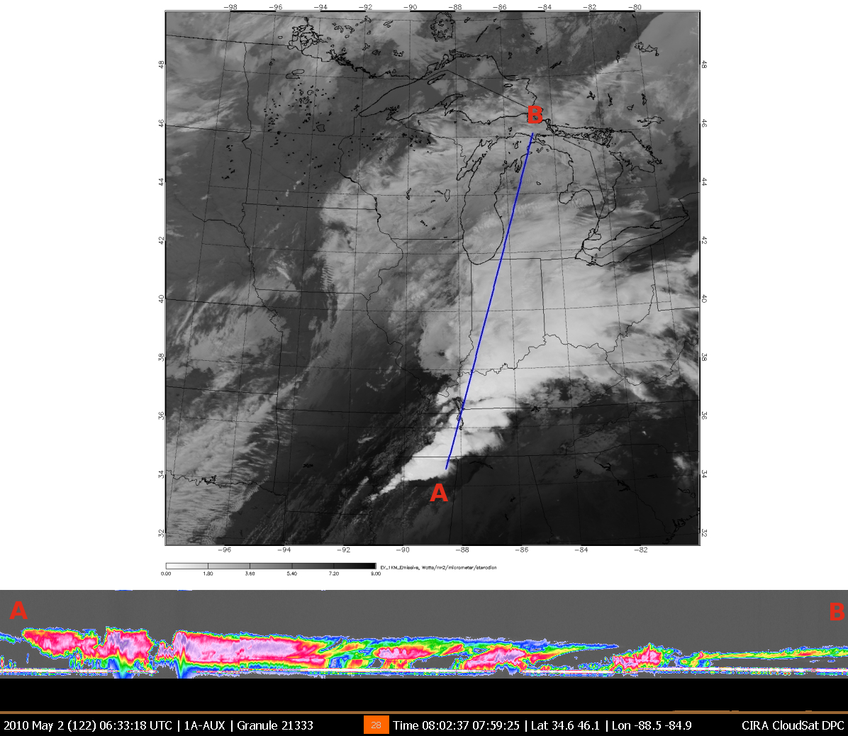
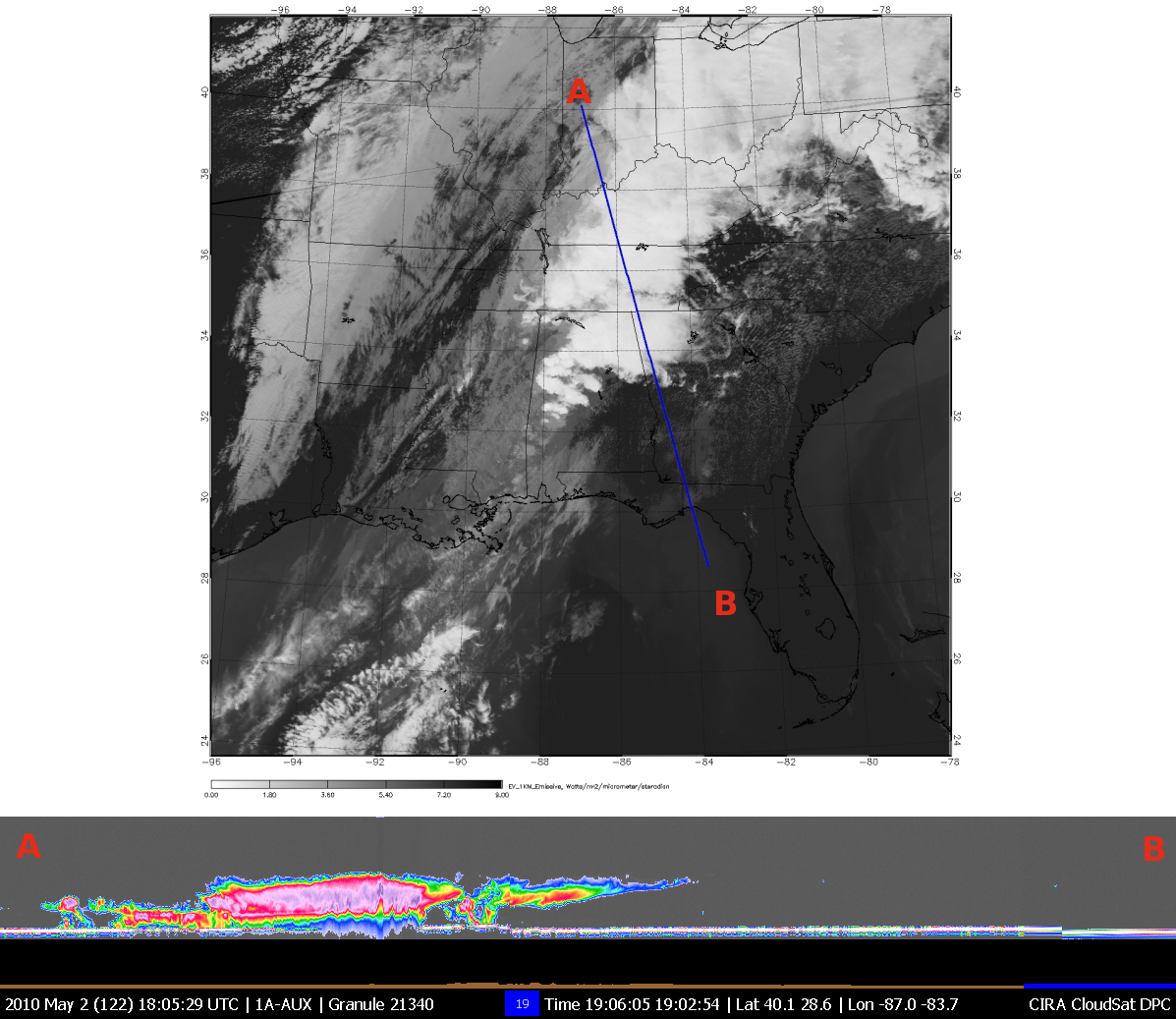
Portions of Tennessee experienced some of the worst flooding on record with more than 16" (40 cm) of rain over the area during May 1-2, 2010. Deep tropical moisture from the Gulf of Mexico and Caribbean fed the intense storms ahead of a slow moving cold front. CloudSat overpassed the area twice on May 2 (0800 & 1900 UTC). CloudSat slices through the tall cumulonimbus clouds revealing the structure of the storm.
CloudSat intersected a storm system moving across New England on March 30, 2010. This storm brought large amounts of rain (3-8 inches) and snow at higher elevations to an already saturated area. Thousands of residents lost power and were evacuated as streams and rivers in the area started to overflow. Record amounts of rains up to nearly a foot for the month of March were recorded in New York and Connecticut. The CloudSat overpass slices through the western part of the storm revealing the large swath of bright reflectivity indicating large amounts of water falling as rain. The comma shaped system is indicative of a mature midlatitude storm system.
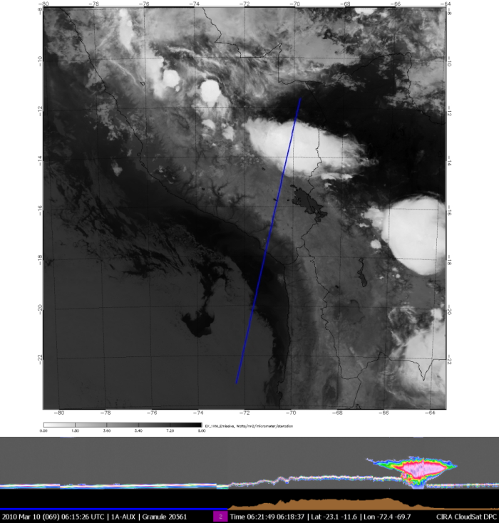
CloudSat overpassed a single cell thunderstorm on March 10, 2010 NE of the Andes Mountains. Moist air from the east is being pushed up against the mountains, fueling thunderstorm development as viewed from the MODIS satellite image. CloudSat captures the vertical development of the storm, precipitation is most likely falling at the base and the top of the storm (anvil) is moving outward away the storm center. Thunderstorms such as these are frequent in this area during the southern hemisphere summer.
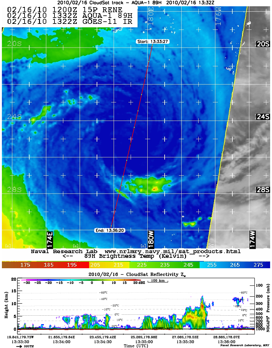
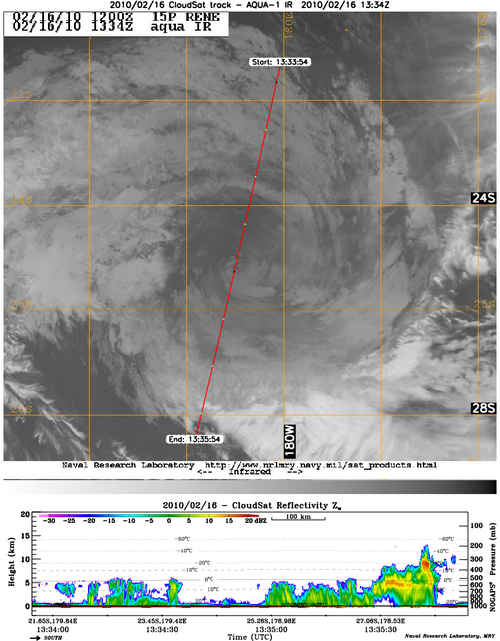
Tropical cyclone Rene, located to the east of Australia and at one stage a powerful category 4 storm, weakens as the circulation moves SW across an area of unfavorable TC formation (lower SST's) in the South Pacific on Feb. 16, 2010. CloudSat intersected through the center of the storm revealing the low clouds associated with the weak surface low. Nearly all of the deep convection and heavy precipitation has been reduced to stratus/cumulus deck (darker grey clouds on the IR image and an absence of cold cloud tops in the AMSR-E image) with cloud top heights below 5km.