|
News: Hurricane Paula
|
 |
|
Hurricane Paula
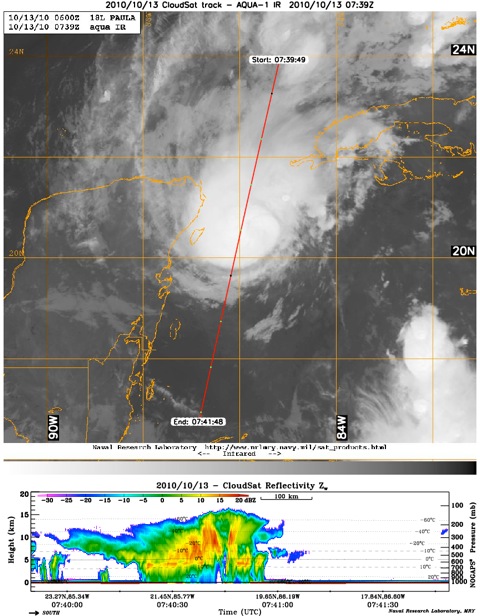
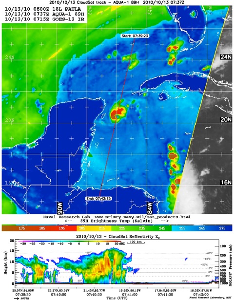
CloudSat overpassed Hurricane Paula on October 13, 2010 at 0740 UTC with winds around 85 knots and a central minimum pressure of 984 mb. Hurricane Paula, a weak category two hurricane currently located between Cancun and Cuba, is a small and compact storm with an estimated eye diameter of 10 nautical miles and hurricane strength winds extending only 15 miles outside of the storm center. CloudSat radar imagery reveals the intense eyewall convection over 16 km on either side of the cirrus hidden eye. Most of the deep convection and heavy rainfall is located to the north and west of the storm center according to the AMSR-E imagery. Strong southerly shear upwards of 20 knots limits storm development in the southern quadrant. The deep red convective eyewall cells of the AMSR-E imagery reveal very low brightness temperatures, most likely ice accumulating in the upper parts of troposphere from strong updrafts. Heavy rainfall from the deep convection attenuates (dampens the radar signal) below 4 km. The eye of the storm is denoted by the small area of no convection below 7 km between the two deepest convective eyewall cores. Above 7 km, the eye area is overlaid by cirrus and cirrocumulus. The eyewall cells slope outward and away from the storm center, a feature typically found in the structure of a hurricane.
Paula is forecasted to interact with the westerly flow and turn to the northeast possibly making landfall in Cuba.
Animation of Paula overpass - 10/13/2010, courtesy of JPL.
|


