|
Education: Satellites
|
 |
|
Meet the Satellites in the A-Train

What is the "A-Train"?
The A-Train is a set of 5 satellites that are planned to orbit in the same orbital plane one after the other in pretty close spacing. It is approximately 15 minutes from the front satellite to the rear satellite and some of them are within a minute of each other. The A-Train is led by the Aqua satellite. Next are CloudSat and CALIPSO followed by Parasol and then Aura pulling the rear. All five satellites cross the equator within a few minutes of one another at around 1:30 pm (13:30) local time. Since these satellites are flying in tandem, the set of satellites is referred to as a constellation, or alternatively, as a formation.
Since this constellation is composed of missions with the equator crossings in the early afternoon (and also in the middle of the night, at about 1:30 am {1:30}), it is referred to as the Afternoon Constellation to distinguish it from the Morning Constellation consisting of Terra, Landsat-7, SAC-C and the New Millennium Programs Earth Observing-1 (EO-1).
Because the satellites are in close formation with each other, they pass over a given spot on earth fairly quickly one after the other. This is beneficial because we can combine data from instruments on the different platforms into combined measurements. It is almost as if all these instruments are on the same platform because they are getting an almost simultaneous view of a certain spot on the ground or in the atmosphere.
The term A-Train comes from an old jazz tune, Take the A-Train composed by Billy Strayhorn and made popular by Duke Ellingtons band, and has become a popular nickname for the Afternoon Constellation because Aqua is the lead member of the formation and Aura is in the rear. The other missions that make up the A-Train are CloudSat, CALIPSO and PARASOL. Each individual mission has its own objectives and will improve our understanding of aspects of the Earths climate.
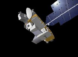
Aqua
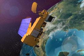
The Aqua mission is a part of the NASA-centered international Earth Observing System (EOS). Aqua will help to provide answers to the subtle changes around the world that influence our environment. The name "Aqua", Latin for "water", is tied to the large amount of information that the mission will be collecting about the Earths water cycle, including evaporation from the oceans, water vapor in the atmosphere, clouds, precipitation, soil moisture, sea ice, land ice, and snow cover on the land and ice. Additional measurements also include radiative energy fluxes, aerosols, vegetation cover on the land, phytoplankton and dissolved organic matter in the oceans, and air, land, and water temperatures. Comprehensive measurements taken by its onboard instruments will allow scientists to assess long-term change, identify its human and natural causes and advance the development of models for long-term forecasting.
On-board Instruments:
- MODIS - Moderate Resolution Imaging Spectroradiometer
- AIRS - Atmospheric Infrared Sounder
- AMSU-A - Advanced Microwave Sounding Unit-A
- HSB - Humidity Sounder for Brazil
- AMSR-E - Advanced Microwave Radiometer for EOS
- CERES - Cloud's and the Earth's Radiant Energy System
Aqua Mission Page
|
CloudSat
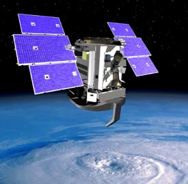
CloudSat is in the process of providing, from space, the first global survey of cloud profiles and cloud physical properties, with seasonal and geographical variations, needed to evaluate the way clouds are parameterized in global models, thereby contributing to improved predictions of weather, climate and the cloud-climate feedback problem. CloudSat measures the vertical structure of clouds and precipitation from space primarily through 94 GHz radar reflectivity measurements, but also by using a combination of observations from the A-Train.
CloudSat has the following science objectives:
- Evaluate the representation of clouds in weather and climate prediction models.
- Evaluate the relationship between cloud liquid water and ice content and the radiative properties of clouds
- Evaluate cloud properties retrieved using existing satellite measurements and promote the development of new remote sensing methods for observing clouds.
- Contribute to an improved understanding of the indirect effect of aerosols on clouds by investigating the effect of aerosols on cloud formation.
On-board Instruments:
- CPR - Cloud Profiling Radar
CloudSat Mission Page
|
CALIPSO
CALIPSO (Cloud-Aerosol Lidar and Infrared Pathfinder Satellite Observation satellite) is providing new insight into the role that clouds and atmospheric aerosols (airborne particles) play in regulating Earth's weather, climate, and air quality.
CALIPSO combines an active lidar instrument with passive infrared and visible imagers to probe the vertical structure and properties of thin clouds and aerosols over the globe. CALIPSO was launched in April 2006 with the cloud profiling radar system on the CloudSat satellite.
CALIPSO and CloudSat are highly complementary and together will provide new, never-before-seen 3-D perspectives of how clouds and aerosols form, evolve, and affect weather and climate.
CALIPSO is a joint U.S. (NASA) and French (Centre National d'Etudes Spatiales/CNES) satellite mission with an expected 3 year lifetime.
On-board Instruments:
- CALIOP - Cloud-Aerosol Lidar with Orthogonal Polarization
- IIR - Imaging Infrared Radiometer
CALIPSO Mission Page
|
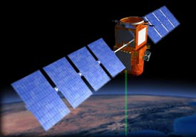
PARASOL
PARASOL (Polarization and Anisotropy of Reflectances for Atmospheric Sciences coupled with Observations from a Lidar) will evaluate the radiative budget of the earth. It is carrying a wide-field imaging radiometer/polarimeter called POLDER (Polarization and Directionality of the Earths Reflectances). POLDER is designed to improve our knowledge of the radiative and microphysical properties of clouds and aerosols by measuring the directionality and polarization of light reflected by the Earth-atmosphere system.
There is a desire to be able to quantify PARASOL's response to anthropogenic modifications and its evolution through time. In order to achieve this, we need to improve our knowledge of direct and indirect radiatives. It is also necessary to better understand the interactions between liquid and solid particles in the atmosphere and the radiance, which are conditioned by the clouds and aerosols radiative and microphysical properties.
On-board Instruments:
- POLDER - POLarization and Directionality of the Earth's Reflectances
PARASOL Mission Page
|
Aura
Aura (Latin for breeze) is part of the Earth Observing System (EOS), a program dedicated to monitoring the complex interactions that affect the globe using NASA satellites and data systems. Aura is designed to answer questions about changes in our life-sustaining atmosphere.
Aura's on-board instruments, HIRDLS, MLS, OMI, and TES, contain advanced technologies that have been developed for use on environmental satellites and will study the atmospheres chemistry and dynamics. Each instrument provides unique and complementary capabilities that will enable daily global observations of Earth's atmospheric ozone layer, air quality, and key climate parameters.
Aura's measurements will provide accurate data for predictive models and provide useful information for local and national agency decision support systems.
On-board Instruments:
- HIRDLS - High Resolution Dynamics Limb Sounder
- MLS - Microwave Limb Sounder
- OMI - Ozone Monitoring Instrument
- TES - Tropospheric Emission Spectrometer
Aura Mission Page
|
|


